 Lassen Volcanic National Park - (3.6 Miles; O&B) - Terrace, Shadow & Cliff Lake Trail
Lassen Peak HighwayMineral , California 96063
Shasta County
Phone: 530-595-4480
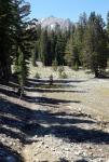
This trail offers incredible views and three beautiful lakes within a four mile round-trip adventure. The trail is well maintained and easy to navigate as you work your way from lake to lake.
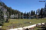
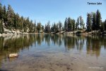
The trail begins with a slight decline down to Terrace Lake which you'll run into less than half a mile after you begin. There are some small beach areas around the lake and it's a great place to stop and chill, have a picnic or just take in the serenity this lake has to offer.
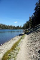
As you leave Terrace Lake, the trail goes up just slightly before dropping down to Shadow Lake. The stunning views of Shadow Lake begin as you move down the trail and only get better as you approach. Once you get to Shadow Lake, you can't miss Mt. Lassen standing strong just off in the distance. It is only 2/10ths of a mile between Terrace and Shadow Lakes. This would also be a great place to relax with a picnic or play in the water.
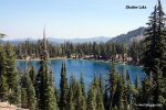
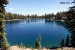
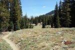
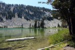
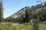
From Shadow Lake, it's exactly one mile to reach Cliff Lake. This part of the trail opens up quite a bit giving hikers great views of surrounding meadows and beyond. As you walk along the trail, you'll see a sign where you'll need to take a right to reach Cliff Lake. If you keep going straight, you'll hit Summit Lake along Highway 89. Cliff Lake is the most secluded of the three lakes and is surrounded on one side by towering cliffs (hence the name) that are pretty humbling as you gaze up.
Distance: It's 3.6 miles, round-trip.
Degree of Difficulty: Easy to Moderate
Dogs: No
Camping: Check out our section about Camping at Lassen for places to camp within the park.
More info:
Bring lots of water. The trail declines the whole way to Cliff Lake which means you're heading up the entire way back. If you're short on time, the round-trip hike to Shadow Lake is only one mile. You can also hike through to Summit Lake which is 3.7 miles each-way. Visit our section on Lassen Volcanic National Park for more fun things to do while you're there.
How to get there:
From the South entrance, the trailhead is a short distance after the Lassen Peak parking lot. There is a sign on the side of the road for the trailhead and a few places to park along the side of the road. Take a look at the map above for the exact trailhead location and be sure to grab a map at the park's entrance station.
*Click on the photos to enlarge them