 Redding - (6.25 Miles; One-Way) - Clear Creek Greenway Trail
Clear Creek RoadRedding, California 96001
Shasta County
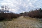
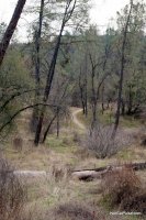
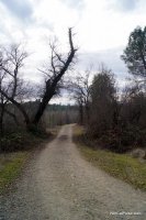
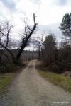
The Clear Creek Greenway Trail is a 6.25 mile trail (one-way) that runs along Clear Creek in Southwest Redding. The trail is pretty much flat from start to finish and is very manageable for almost everyone.
Our map shows the location of the Gold Dredge Trailhead which is the most eastern trailhead (closest to Highway 273). The most western trailhead is near Horsetown Clear Creek Preserve. There are also a few trailheads in between so you can explore it in segments or from one end to the other.
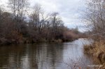
Because the trail runs along Clear Creek, there are plenty of places along the way that give walkers, bikers and horse riders access to the creek.
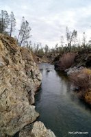
The trail is just close enough to Redding to make it convenient but also in an area that makes it feel remote. Pack some food and stop somewhere along the way, like the Clear Creek Gorge Overlook, for a relaxing picnic before finishing up the hike.
During the spring and early summer, wildflowers color the area beautifully and during spawning season, there are quite a few places to see Salmon making their run.
Distance: 12.5 miles round-trip or break the trail into smaller segments.
Degree of Difficulty: Easy
Dogs: Yes, on leash only
More info:
Bring plenty of water when you hike this trail. Good shoes are recommended. Here is a MAP of the trail system.
How to get there:
From Highway 273, north of Anderson, take Clear Creek Road west. You'll see signs for the trailheads along the road so you can pick the trailhead where you want to start.
*Click on the photos to enlarge them