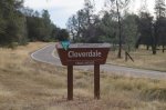
Redding - (Up to 6 Miles) - Cloverdale Trailhead
Cloverdale RoadRedding, California 96047
Shasta County
The Cloverdale Trailhead southwest of Redding is the trailhead to two different, very manageable trails. There are restrooms at the trailhead but no drinking water so be sure to bring some.
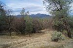
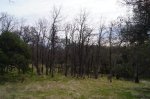
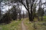
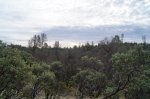
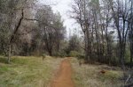
Cloverdale Loop (1.73 miles) - Short but beautiful dirt loop trail with a nice, well maintained path and slight rolling hills. Great views of the surrounding area can be seen from this trail. Hikers, bikes (mountain), dogs (on leash) and horses are welcome on this trail. There is a slight deviation from the main trail that allows you to check out Clear Creek as you enjoy the trail.
Piety Hill Loop (3.85 miles) - The Piety Hill Loop trail also has a well maintained dirt path that is open to hikers, dogs (on leash), bikes (mountain) and horses. This trail has slightly rolling hills that are a bit more intense than those on the Cloverdale Loop but still very manageable. The Piety Hill Loop Trail also connects to Horsetown Clear Creek Preserve which also has a short loop so you could increase the length of this hike by an extra mile or so if you wanted to.
Here is a MAP of both of these loops.
How to get there:
There are a few ways you can get to the trailhead including from Clear Creek Road in Anderson, Placer Road in Redding and Platina Road from Platina and Ono. Check out the map for your best route to get there.
*Click on the photos to enlarge them