Lassen Volcanic National Park - (4 Miles; O&B) - Cinder Cone
Butte Lake RoadOld Station (11 miles east of), California 96071
Lassen County
Phone: 530-595-4480
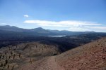
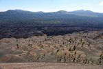
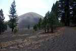
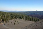
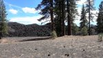
The Cinder Cone hike is simply awesome and offers a number of sweet rewards. The views of the surrounding area, the access to Painted Dunes, the towering lava beds, views of Butte and Snag Lakes and the peaceful environment are just a few of the things that draw people to this hike.
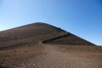
The trail, from start to finish, is on loose cinders which can often feel as difficult as walking on sand. We suggest wearing hiking boots that give your ankles some support.
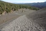
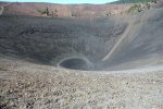
The main trail leads hikers up to the top of the cone and gives access to its pit. From the top, there is another trail that drops down the backside of Cinder Cone into the Painted Dunes area and loops back toward the trailhead if you choose to see Painted Dunes up close (you should).
Even as difficult as this hike might be, we highly encourage people to make the trip out to the Northeast part of the park and take this hike.
Distance: 4-miles round-trip. Should take about 3 hours.
Degree of Difficulty: Moderate ~ The hike itself is not long but is over a loose cinder terrain which can get tiring.
Dogs: No
Camping: The Butte Lake Campground is very near the trailhead. The Hat Creek Campground is about 20 minutes away as in the Cave Campground. Click the link for other Places to Camp at Lassen Volcanic National Park.
More info:
There are bathrooms at the trailhead but none along the way. A visit to Painted Dunes (just to the side of Cinder Cone) is worth the extra mile of walking and Butte Lake (near the trailhead) is a great place for swimming, kayaking, canoeing and other non-motorized lake activities.
Take a look at our section on Lassen Volcanic National Park for more information and other things to do while you're there.
How to get there:
Once you turn east on Highway 44 (Old Station) from Highway 89, the turn is on your right about 11 miles down the road. You'll see a sign for it on Highway 44. The trailhead is about 6 miles down the road once you leave Highway 44. You'll find it in the Butte Lake Day-Use Area. Check out the map for more specific directions.
*Click on the photos to enlarge them